

18 March, 2019
![]()
“Consequently, farmers often uniformly fertilize and water fields, regardless of which areas need more or less. UAVs could help achieve effective precision agriculture, saving money and resources and growing better quality crops.”
Ziliani set out to show that the imaging data collected by UAVs is as useful as data retrieved by more expensive LiDAR laser scanning. To do this, the team took multiple images of the same 50-hectare maize field at different points throughout the growing season—one set of color images taken by UAV and the other by ground-based LiDAR. The researchers used each image set to build three-dimensional canopy models and to compare how closely the UAV images replicated the accurate LiDAR data.
“We can create three-dimensional models of objects using sets of two-dimensional images taken from different angles in the same way as the human brain processes our binocular vision,” says Ziliani.
The digital field maps generated using UAV data provided an accurate representation of crop height over time, comparable to those created using LiDAR. Ziliani acknowledges that further work is needed, for example, the computational power required to process the data is currently too large to be processed by an average desktop computer.
Also, when the plants were very young, the UAV struggled to pick up their structural details. This could be resolved by flying at lower levels, but this limits the area covered in the available flight time, which is in turn linked to battery life. Indeed, battery life will need to be improved if UAV technology is to meet its potential in monitoring crops across larger regions, searching for pockets of productive and unproductive land, or examining storm damage.
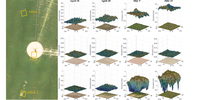
UAVs can help farmers to detect problems in the field at critical stages of the season. The image shows three subareas in the maize field and their development during the growing cycle. This includes: a healthy region (Area 1), a static bare-soil region (Area 2) and an affected region (Area 3).